If you access the Burdekin Shire Council – Burdekin Public Mapping System you will be taken to have agreed to the following conditions of access:
The contents of this website (which includes downloadable material) are subject to copyright and are protected by the laws of Australia and other countries through international treaties.
Burdekin Shire Council grants you a non-exclusive licence to reproduce the contents of this website:
- in your web browser (and in any cache file produced by your web browser); and
- on a printout, for the sole purpose of viewing the content.
Burdekin Shire Council reserves all other rights.
The information on this website has been taken from Council’s databases and the Department of Natural Resources and Mines mapping, as well as from Open Street Map content.
It is made available in good faith but its accuracy and completeness are not guaranteed. If you intend to rely on any information from Council you should apply to the Council in writing for that information.
Council is not responsible for, and gives no guarantee concerning, the contents of any linked website or any link contained in any linked website.
To the maximum extent permitted by law, Council excludes all liability to you for loss or damage of any kind and however caused, including by negligence, arising from or relating in any way to the contents of this website and/or your use of it.
All matters relating to this website are governed by the laws of the State of Queensland, Australia.
Introduction
Before proceeding, please ensure you have read and accepted the Conditions of Use.
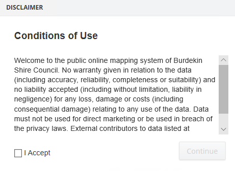
Example of the GIS Conditions of Use
Anyone can access the site and use the map if they have a PC or mobile device with a web browser and an internet connection. You can use the web map to search for addresses, lots on plans, easements and roads in the Burdekin Shire. In addition, tools are available to measure distance or area, print a map and obtain coordinates for locations.
The map shows cadastral information from the Department of Natural Resources, Queensland Digital Cadastral Database (DCDB) for the Burdekin local government area.
Information about properties (land parcels) within the Burdekin Shire is available from the interactive map.
You can interact with the map by panning and zooming with the mouse (or your finger on a touch screen) and by using a selection of tools including a search function, measuring tool, print tool and stored views.
Change map themes
PC: The map themes are listed in the left-hand panel called “Modules”. Select the module of interest by clicking on the module name.
Mobile device: Tap the first icon from the left at the bottom of the map window. This will open the module list. Tap the module of interest to select it.
Show/hide map layers
PC: The map layers are listed in the left-hand panel called “Layers”. Visible layers are those layers which have the checkbox ticked. Hidden layers are unchecked. You can show and hide layers by ticking the relevant checkboxes. Some layers, such as House Number and Road Names, are checked but will not become visible until a specific zoom level is reached.
Mobile device: To open the layer list tap the second icon from the left at the bottom of the map window. Check and uncheck layers as required. Tap the cross in the top right of the layer list to close the list.
Map Legend (PC Only)
To enable the legend click on the legend icon in the top right-hand corner  .
.
This will enable a pop-up legend to be displayed in the map window, which will display the dynamic legend for all items currently displayed in the map window. This legend can be dragged around to a different location using the mouse and can be closed by clicking on the close X in the top right-hand corner of the legend pop-up.
Navigating around the map
When you first load the map it will be centred on the entire extent of the Local Government Area. You can zoom to specific urban areas such as Ayr, Home Hill and Brandon using the navigation tools explained below.
Get back to this home location (PC only)
Click the house icon  which is located on the “Navigation” tab of the “View” menu bar.
Find your current location
If your device has a GPS or your browser is able to share your location, you can find your current location by clicking (or tapping) the GPS tool icon  which is found on the “Info” tab of the “Tools” menu bar.
Navigating the map by panning
Click the left mouse button and drag the mouse to move around the map or use the “Pan” tool  located on the “View” menu bar.
On touch screens you can slide the map around with your finger.
Zooming in and out
Roll the mouse wheel back and forth to zoom out and in on the map or use the “Zoom In” tool  or the “Zoom Out” tool
  found on the “Navigation” tab of the “View” menu bar.
To zoom in on a touch screen, touch two points on the map and then move your fingers away from each other as if you are stretching them apart.
To zoom out on a touch screen, touch two points on the screen and then move your fingers toward each other as if you are pinching them together.
Displaying information about a land parcel
Click on a land parcel to obtain the following attribute information:
- Lot on Plan
- Physical Address
- Tenure
- Google Map Link *
- Parcel Count ~
- Perimeter (m)
- Area (sqm)
- Garbage Waste Area
- Storm Tide Evacuation Zone
- General Waste Collection Day
- Next Recycle Waste Collection Date
- Green Waste Collection Day
* The Google Map hyperlink can be used to link to open Google Maps at the selected address.
~ The number of parcels that make up that Lot on Plan.
Searching for a property, easement or road
PC: Located at the bottom of the map window are four search tabs – Address Search, Lot on Plan Search, Easement Search and Road Name Search.
Click on the tab displaying the type of search required and enter the relevant details.
A pick list will display in a dropdown box as you type in the search field. Select the suggestion that matches your search request and click on the Search button.
Mobile device: Tap the magnifying glass on the right at the bottom of the map window to open the search options. Tap the search option required, enter the relevant details and tap the Search button.
Measuring distance or area
These tools are located on the “Info” tab of the “Tools” menu:
Measure Distance: 
Measure Area: 
Select the tool required and click on the map at each vertex of measurement. Double click to complete the measurement. The measurement results will be displayed both on the map and in a results window.
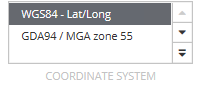
Finding the coordinates of a point on the map (PC only)
Use the “Coordinate” tool  on the “Info” tab of the “Tools” menu.
Select the tool and click on the map at the required location. The coordinates and coordinate system will be displayed. The default coordinate system of the map is GDA94/MGA Zone 55. If latitude and longitude coordinates are required change the coordinate system first by selected WGS84 (lat/long) on the “Coordinate System” tab located on the “View” menu:
Annotating a map (PC only)
Text, points, lines and polygons can be drawn on your map using the tools provided in the “Shape” tab on the “Annotation” menu.
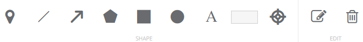
Click on the shape type and choose the colour and size. Then start drawing on your map.
When the text icon is selected, choose the colour and size and then enter your text in the text box. Click on the map at the location where the text is to be displayed.
Delete the drawing by selecting the “Delete” icon  from the “Edit” tab and then clicking on the drawing
Edit the drawing by selecting the “Edit” icon  from the “Edit” tab and then clicking on the drawing. Editing will allow you to rotate or move the drawing.
Aerial Imagery (not available on some mobile devices)
Aerial imagery captured in 2018 is available to be used in Burdekin Shire Council Public IntraMaps. To enable the aerial imagery use the Aerial Imagery slider tool located at the top left hand corner of the map window.
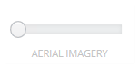
By sliding the slider to the right, the aerial imagery will begin to display as the map window becomes transparent. To completely enable the 2018 aerial imagery, slide the slider all the way to the right. To partially display the aerial imagery only slide the slider a portion of the way along the slider. Sliding the slider completely to the left will turn the imagery off and make the map window non-transparent again.
Printing a map (PC only)
Printing has only been enabled for the “Property Public” map module.
At the top right hand corner is a small printer icon. Click on this “Print” icon to begin the print process 
A print settings box will open allowing you to customise your print. Options include choosing an A4 or A3 template in Portrait or Landscape, printing to PDF or Word, selecting a scale and choosing vector or raster format. When you are satisfied with your settings, click the Print button. If you chose to print to PDF, your map will open in a separate browser window. From here you can save or print the map. If you chose to print to Word, the map will open in your default document application (.docx) where you can save or print the map.
To enable Aerial Imagery in the print ensure you click on the Include Slider – Aerial Imagery tick box.

Online Help (PC only)
The IntraMaps 9.10 Online Help is available by clicking on the help icon in the top right-hand corner (located near the print button and legend button)  . Clicking on this button will open the online help. Please be aware this is the help document for the entire IntraMaps application and some information in the online help will not apply to Burdekin Shire Council Public IntraMaps.